Search Term Record
Metadata
Name |
Dry Gulch Road |
Number of Archive records |
0 |
Number of Object records |
0 |
Number of Library records |
0 |
Number of Photo records |
13 |
Related Records
-
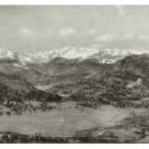
1972.013.001 - Print, Photographic
Black and white panorama view of the Estes Valley in 1903, before much development. Visible sights include the Big Thompson River and Meadow, Lumpy Ridge, Castle Mountain, MacGregor Mountain, Mummy Range, Deer Mountain, Prospect Mountain, Old Man Mountain, Twin Sisters, etc. Marks: Bottom LH corner "Estes Park, Colorado"/ Copyright 1903 by H.C. Rogers" in white letters. Lower Right hand corner in white: Reproduced from a photograph by the...
Record Type: Photo
-
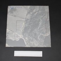
1992.030.007 - Print, Photographic
Aerial photograph #5-72, 20 Dry Gulch. Mounted on heavy cardboard with a plastic overlay sheet with markings taped over top of photograph. This photograph (7 of 25) was given to Ralph Read By Giles Gene. The photos were used by Upper Thompson Sanitation District at the time of their organization. These photos are arranged by section number in east-west order as labelled in red on the attached map. Also used to plan spraying from helicopter...
Record Type: Photo
-
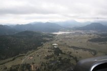
2015.001.007 - Photograph
8 digital photographs, aerial photographs of Dry Gulch Road during September 2013 flood
Record Type: Photo
-
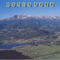
2016.005.0349 - Postcard
Postcard featuring an aerial view of Estes Park looking towards Longs Peak and the Range with Lake Estes, Prospect Mountain, and the town in the foreground. Visible sights include Dry Gulch Road, Highways 34 and 36, the Olympus Dam, etc. Caption printed on reverse reads, "Estes Park, Colorado. A panoramic aerial view of Lake Estes, Estes Park, and Longs Peak - one of the oldest family resorts in Colorado. Photograph by Thorney Lieberman." ...
Record Type: Photo
-
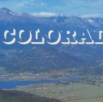
2016.005.0356 - Postcard
Postcard featuring an overview of Estes Park, looking towards Prospect Mountain, Longs Peak, and the Range. Sights visible include Lake Estes, Dry Gulch Road, the Olympus Dam, Marys Lake Lodge, the Fairgrounds / Stanley Park, etc. Caption printed on reverse reads, "Estes Park, Colorado aerial view with Longs Peak in background. Color Photo: Mountain States Specialties, Inc." Publication information, "Mike Roberts, Oakland, CA 94623" "M...
Record Type: Photo
-
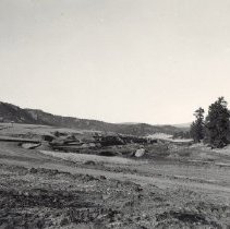
2017.024.012 - Print, Photographic
Photograph featuring a view of the construction of the Olympus Dam and Lake Estes in the late 1940s. View is taken with a portion of Lumpy Ridge to the left of the image, and a good view of Highway 34 including the bridge which is still present today. This view looks towards Dry Gulch Road, where the present day Sombrero Ranch Stables and KOA campground are. In the foreground of the image, construction equipment, mounds of dirt, men, and build...
Record Type: Photo
-
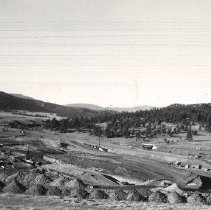
2017.024.025 - Print, Photographic
Photograph featuring a view of the construction of the Olympus Dam and Lake Estes in the late 1940s. Overview of the construction area, featuring men working, and a large crane. Highway 34 and Dry Gulch Road visible in background. The Olympus Dam was constructed between 1947-1949 along the Big Thompson River in Estes Park, creating Lake Estes. As part of the Colorado-Big Thompson Project, Lake Estes is located east of downtown Estes Park ...
Record Type: Photo
-
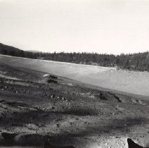
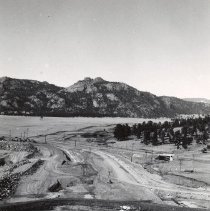
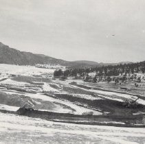
2017.024.071 - Print, Photographic
Photograph featuring a view of the construction of the Olympus Dam and Lake Estes in the late 1940s. Overview of the land near the construction site, and ditch where the pipe would be laid, looking towards Dry Gulch with a portion of Lumpy Ridge visible. The Olympus Dam was constructed between 1947-1949 along the Big Thompson River in Estes Park, creating Lake Estes. As part of the Colorado-Big Thompson Project, Lake Estes is located east ...
Record Type: Photo
-
2017.024.072 - Print, Photographic
Photograph featuring a view of the construction of the Olympus Dam and Lake Estes in the late 1940s. Overview of the land near the construction site, and ditch where the pipe would be laid, looking towards Dry Gulch with a portion of Lumpy Ridge visible. The Olympus Dam was constructed between 1947-1949 along the Big Thompson River in Estes Park, creating Lake Estes. As part of the Colorado-Big Thompson Project, Lake Estes is located east ...
Record Type: Photo
-
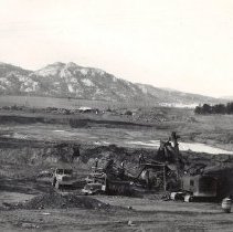
2017.024.086 - Print, Photographic
Photograph featuring a view of the construction of the Olympus Dam and Lake Estes in the late 1940s. Overview of the construction site looking towards Lumpy Ridge, with men, equipment, and trucks visible in foreground. Looking towards Dry Gulch Road. The Olympus Dam was constructed between 1947-1949 along the Big Thompson River in Estes Park, creating Lake Estes. As part of the Colorado-Big Thompson Project, Lake Estes is located east of do...
Record Type: Photo
-
2017.024.094 - Print, Photographic
Photograph featuring a view of the construction of the Olympus Dam and Lake Estes in the late 1940s. View of a roadway in the interior of a construction site with several automobiles visible. This image features the second part of the dam looking back into Dry Gulch. The Olympus Dam was constructed between 1947-1949 along the Big Thompson River in Estes Park, creating Lake Estes. As part of the Colorado-Big Thompson Project, Lake Estes is l...
Record Type: Photo