Search Term Record
Metadata
Name |
Maps |
Number of Archive records |
315 |
Number of Object records |
14 |
Number of Library records |
2 |
Number of Photo records |
42 |
Related Records
-
1966.024.023 - Postcard
Greenish blue card with drawing of man of Longs Peak Trail. Back of card has small drawing of the back of Longs Peak plus a place for address and postage.
Record Type: Photo
-
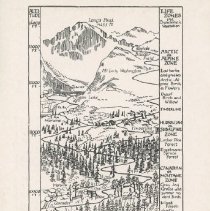
1966.024.024 - Postcard
White with drawing of the Longs Peak Trail on front, showing Altitude and Life Zones. Back has "POSTCARD" with place for message, postage and address.
Record Type: Photo
-
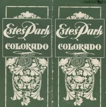
1969.024.035 - Brochure
Brochure, green cover with white text and design reading 'Estes Park / Colorado' Interio fold has map of Estes Park and area. Bifold, staple bound on one edge. Page 1-- includes description of Estes Park and location, how to get to Estes (listing train travel then stage from Lyons), lists hotels and boarding houses (Estes Park Hotel, Elkhorn Lodge, the Highlands, Sprague's, and Long's Peak House), lists camp and cottage life. Page 2-- ...
Record Type: Object
-
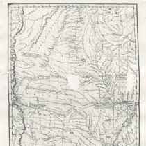
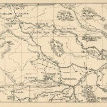
1970.037.181 - Map
Canvas map of the western european countries involved in World War I. Black and red on white cloth. Comes with an index (1970.037.182.a) and manilla envelope (1970.037.1982.b).
Record Type: Object
-
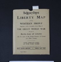
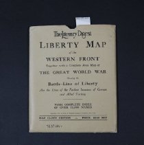
1970.037.181b - Envelope
Envelope to hold map and index of western european countries involved in World War I. On the outside of the envelope in black letters "The Literary Digest Liberty Map of the Western Front, Together with a complete area map of "The Great World War" etc. Priced at $4.50 Includes index (1970.037.0182a) and map (1970.037.181) Produced by Funk & Wagnalls Company
Record Type: Object
-
1980.010.005 - Print, Photographic
Country drained by the Mississippi Western Section.
Record Type: Photo
-
1981.078.007 - Postcard
Tan card with "Road and Trail Map of Vicinity of Estes Park, Colorado." by E.F. Gillette. The reverse side has "Postcard" at top and a dividing line - one side for message and right side for address. Stamp square in upper right hand corner.
Record Type: Photo
-
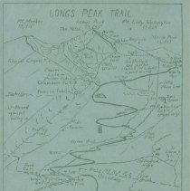
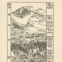
1981.086.010 - Postcard
Front has black ink drawing of The Longs Peak Trail with points of interest, altitude, scale and life zones and characteristic vegetation. Copyrighted by Mrs. Enos A. Mills 1923
Record Type: Photo
-
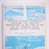
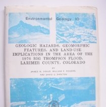
1982.019.001 - Map
Geologic Hazards, Geomorphic Features, and Land Use Implications in the area of the 1976 Big Thompson Canyon Flood. Colorado Geological Survey/ Environmental Geology 10/ Plate 1 of 4. by James M .Soule and William P. Rogers. All four maps are in a folder.
Record Type: Object
-
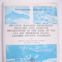
1982.019.002 - Map
Geologic Hazards, Geomorphic Features, and Land Use Implications in the area of the 1976 Big Thompson Canyon Flood. Glen Haven quadrangle. By James M. Soule, William P Rogers and David C. Shelton. Plat 2 of four.
Record Type: Object
-
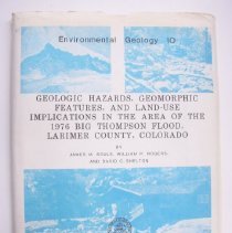
1982.019.003 - Map
Geologic Hazards, Geomorphic Features, and Land Use Implications in the area of the 1976 Big Thompson Canyon Flood. Colorado Geological Survey/ Environmental Geology 10/ plate 3 of 4. By James > Soule, William P. Rogers and David C. Shelton. All 4 maps are in a folder.
Record Type: Object
-
1982.019.004 - Map
Geologic Hazards, Geomorphic Features, and Land Use Implications in the area of the 1976 Big Thompson Canyon Flood. July 31-August 1, 1976. Follows river and road to show devastation with notes. By James M Soule, William P. Rogers and David Shelton, Plate 4 of 4.
Record Type: Object
-
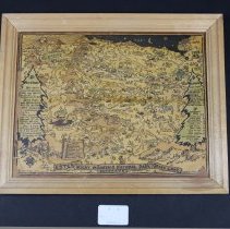
1986.121.001 - Map
Caricature map of Estes Park, Rocky Mountain National Park, and Grand Lake. Richardson Rome is the artist. Mileage for auto roads and horseback trips and shows lodges, mountains, lakes. Framed by donor on a piece of masonite and has a plain pine molding frame. Found at Stead's Ranch
Record Type: Object
-
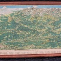
1990.008.002 - Map
Prathers aerial view of Rocky Mountain National-Estes-Park mounted on plywood with a stained molding frame. Map is in shades of green and tan. Top and bottom edge numbered 1-48, 7 sides from a-o for quick identification from sites listed at bottom of map. Left and right corner in ink 'Bighorn Ranger Station' l.l. corner in ink ' loren 7 ruth lane - on twin sisters lookout 1933 .same ladies names -park ranger & district park ranger -1941-1954 ...
Record Type: Object
-
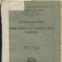
1991.043.001 - Book
Grey paper cover with title "The Geologic Story of Rocky Mountain National Park" at top and Department of Interior logo near bottom. Includes maps of area, photographs and text. Eighty-nine numbered pages- index and 1917 topographic map in envelope pasted in back. Belonged to Raymond J. Pool of Olympus Lodge- a relative of the donor.
Record Type: Object
-
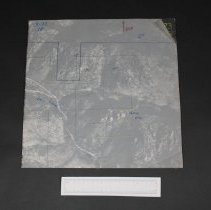
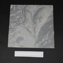
1992.030.001 - Print, Photographic
Aerial photograph #5-72,17 Devils Gulch Rd. A map of the Estes Valley area divided into square sections, numbered in red. Description of the sections depicted by these areial photographs is attached (taped) to this photograph. This photograph is 1 of 25. A note from Ralph Read explaining the set of photographs is also taped to this photograph. Plastic overlay sheet with red line taped over top of photograph. Photograph mounted on heavy card...
Record Type: Photo
-
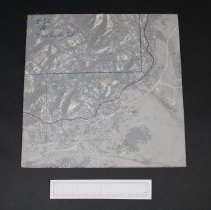
1992.030.002 - Print, Photographic
Aerial photograph #5-72-18 Devils Gulch road mounted on heavy cardboard. Plastic overlay sheet taped over photograph, with red line on overlay; additional blue darkened line, "NPS" in pencil. This photograph (2 of 25) was given to Ralph Read By Giles Gene. The photos were used by Upper Thompson Sanitation District at the time of their organization. These photos are arranged by section number in east-west order as labelled in red on the att...
Record Type: Photo
-
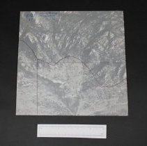
1992.030.003 - Print, Photographic
Aerial photograph #5-73-13 Lumpy Ridge MacGregor. Red line on overlay. Mounted on heavy cardboard with clear plastic overlay. This photograph (3 of 25) was given to Ralph Read By Giles Gene. The photos were used by Upper Thompson Sanitation District at the time of their organization. These photos are arranged by section number in east-west order as labelled in red on the attached map. Also used to plan spraying from helicopter for spruc...
Record Type: Photo
-
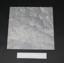
1992.030.004 - Print, Photographic
Aerial photograph #5-73-14 Lumpy Ridge. Red line and blue dotted line on plastic overlay cover, mounted on heavy cardboard. This photograph (4 of 25) was given to Ralph Read By Giles Gene. The photos were used by Upper Thompson Sanitation District at the time of their organization. These photos are arranged by section number in east-west order as labelled in red on the attached map. Also used to plan spraying from helicopter for spruce dud...
Record Type: Photo
-
1992.030.005 - Print, Photographic
Photograph # 5-73-15 one section of 25 of the Estes Valley. Mounted on heavy cardboard with plastic overlay. This photograph (5 of 25) was given to Ralph Read By Giles Gene. The photos were used by Upper Thompson Sanitation District at the time of their organization. These photos are arranged by section number in east-west order as labelled in red on the attached map. Also used to plan spraying from helicopter for spruce dudworm by Estes...
Record Type: Photo